The Low Islands
South Pacific islands, some three to four million years in geological age, are formed by magma bursting through a thin spot in the earth’s crust and throwing up material. Large volumes of basaltic material are pumped up to create an underwater mountain. An island can form above the surface of the sea if the volcanic activity is sufficient sometimes with an active volcano or a large volcanic ridge. If there is only minor volcanic activity the resulting body might just be an underwater shoal or reef. As the earth’s crust moves, the island moves away from the volcanic chimney halting any further growth. When another thin spot appears over the chimney, the magma breaks through again and a new island or shoal is formed. Once volcanic activity has ceased, gravity and erosion will cause the volcanic mountain to both sink and wear away. All that may remain of what was once a volcanic mountain is a large a sunken crater in the middle of an island. Sometimes all that is left in the center of an island is this large water filled crater, giving the distinctive ring shaped appearance associated with south sea atolls.
If volcanic activity is still occurring sometimes a unique geological feature may be produced. The lower volcanic matter may push up coral that has formed just under the water as a whole layer. A distinct vertical layer of coral is then found above water. Some are of short vertical height. Others may have occurred over a long time resulting with successive layers stacking to a great height.
The Tuamotu archipelago is known as ‘The Low Islands’ because they are low in the water and hard to see by ships. If islands are large enough to protrude above the waves, the volcanic material or coral can capture the passing sand as soil to eventually allow vegetation to establish. The island’s stratum is of deposited sand overlying the limestone (degraded coral). This overlies the volcanic material that is generally of a basaltic nature. Contrary to appearances, water can be found on a lot of the atolls, either fresh or brackish. It is usually located by digging just a bit below sea level in the islands soil stratum, as a ‘lens’ of fresh water exists in the sand. It is this fresh water that maintains the coconut palms and other vegetation. A practice for a community on these islands is to sink a permanent well near the village. A small volcanic crater, sunk below ground level, can also act as a well. Captain Brown had pointed one out to John Chetwood on an island they had visited.
If you are following some directional codewords to the Throne of God, be aware that a ‘water source’ can be one of these on these islands.
The island’s shape is dependent on the growth of the coral that is itself dependent on the prevailing climatic conditions. This old diagram and the text that accompanies it explain it quite succinctly.
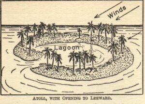
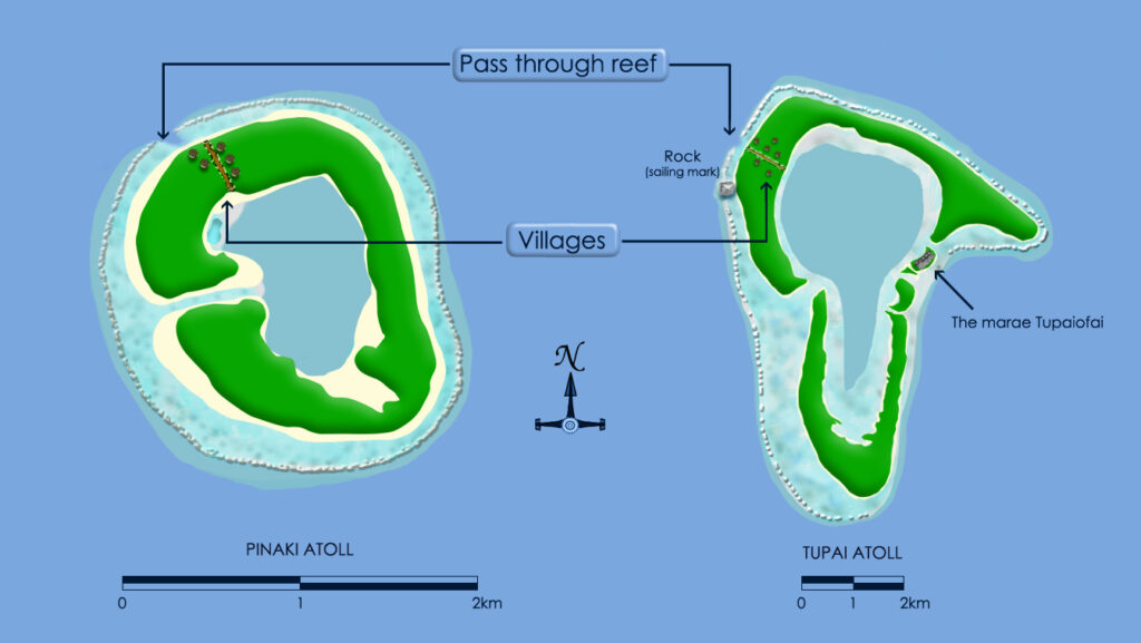
Knowledge of this is important if seeking access to an atoll from a ship. As the windward side has the coral growth, the leeward side will generally be where a pass is located as a gap through the surrounding coral reef to the outer lagoon. Generally villages are established adjacent to the main pass through the outer coral ring for convenient access to the sea.
It seems to be language practice that any water within this outer ring of coral is referred to as the lagoon. This gets confusing where the atolls are of a ring shape and have an internal body of water in the remnant volcanic crater. This is also referred to as the lagoon.
These ring type islands have a landmass that tends to get thicker in height towards the center. The profile increases in height from the outer lagoon’s beach toward the centre of the ring before decreasing again towards the inner lagoon.
Using The Map
Charles Howe had taken Captain Brown’s map. This displayed the position of three islands that had a defined angular relationship in the form of a triangle (Trinity). The distance between the islands in the Trinity were similar to those of the Pinaki and Tupai Trinity groups as these were similar to each other and were the places that Captain Brown had told others to search. No indication of distance between the islands in the Trinity was shown on the map because if it were, Hamilton’s expedition would have been able to determine the Hiti Trinity was too small.
Hiti and Pinaki atolls are in no way similar in shape. Howe had also described a series of directional landmarks that would be encountered; the first being a ‘pinnacle of coral’ on the west side, to the left of which was a pass through the coral reef. Another landmark was that the gold was in a ‘pear shaped pool’, near which was seven blocks of coral set at even distances apart. You can recognise some of the Spanish directional descriptions were being used but not all. Captain Brown never game them all to any person or group he was involved in. It was his final security measure.
Howe had also said that after finding some chests buried on the island, he had reburied the treasure at a position ‘84ft. E. by N. and 75ft. N. by E.’ from the pinnacle.
It is now known that a lot of what Captain Brown, Howe and Hamilton said was lies and that each one had also withheld certain information from the next. This resulted in a progressive loss of understanding as to what was the landmark and what was the target the landmark led to. For example, after following the incomplete clues he was fed by Captain Brown, Howe had searched the land, the shore and the lagoon at a particular location on Pinaki. It was to a pool at this particular location on Pinaki that he directed the Juventin brothers. This (incomplete) background information was not passed to Hamilton who changed the focus and merrily searched every island he landed on until he found a ‘pear shaped pool’ which he then asserted in a backwards sort of way was the proof he had found the correct location.
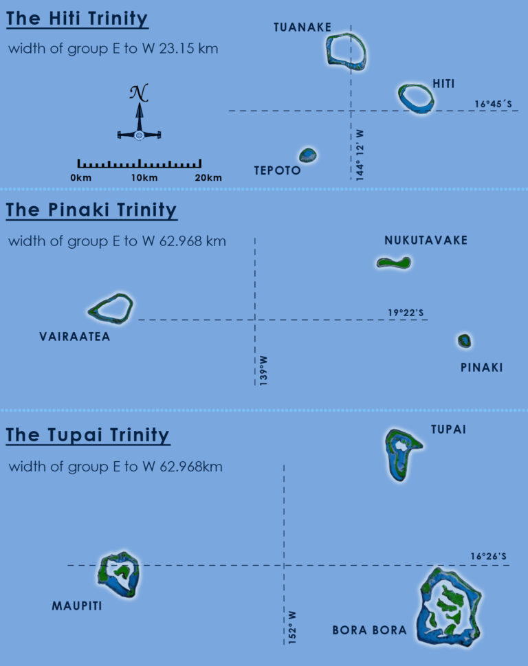
There is also a major anomaly between where Howe and the Genesee expedition had searched. Each Trinity group was made up of three islands in a repetitive pattern; two islands adjacent on the eastern side, one above the other and the remaining island further out to the west. Howe had searched Pinaki, the lower of the eastern islands in that triangle, with the Genesee expedition searching Tupai, the upper eastern island in that triangle. This is the reason why Howe had searched both Hiti and Tuanake.
The particular area Howe focused on for his search on Pinaki is known. Bernard Villaret wrote an article for a magazine in the second half of the twentieth century titled ‘Le vieux “Charley” a-til retrouvé le trésor des flibustiers?’ (Did old Charley find the treasure of the pirates?)
The article tells the base story that Howe got his information from an ancient sailor “Kilrain”, which was confirmed by a “certain Brown, captain of the (ship) Black Sheep” (this is part of the story told to the Herman group). Villaret goes on to speculate that Howe may have really found the treasure on an atoll called Anuanuaro, which is some 350 nautical miles distant from Pinaki as a “troubling document” in the French archives dated 1915 reported that “upon a large rock there was observed the inscription JAT along with a piece of a wooden box found in an empty hole upon which were the characters FICXXXVIII”. The article included a rather distorted map that marked the locations of interest on Pinaki. The legend to the map is a direct translation from the French.
Pinaki Island
A Skeletons of natives of Nukatavake.
B Skeletons of blacks with shots to the head.
C Underwater excavations by compressed air.
D Excavations in the ground.
E Paeakiri village.
F Landing point.
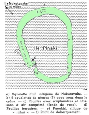
This map indicated Howe had been exclusively focused on the north western sector of Pinaki. The North West sector was the area Nordhoff reported as having been meticulously trenched by Howe.
The “pear shaped pool” was just the same pool Howe had sent the Juventin brothers to search and was where Nordhoff had seen Howe diving into the lagoon years earlier. The landmarks clues Howe passed to Hamilton’s group were just those for Pinaki.
Howe was following a special version of the monument map which was being interpreted as the northwest sector of Pinaki.
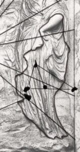
As part of his story Howe claimed he had located three caches on the island; a chest with jewellery, another chest with doubloons and the bulk gold in the lagoon. He claimed he reburied the jewellery from the first chest ‘84 feet E. by N., and 75 feet N. by E.’ from the pinnacle. Howe was aware that the map was multi scaled and that the Golden Section Triangle plotting, apart from indicating the layout of the Trinity islands. The dot, which is not one of the points of the Golden Section Triangle with a line leading off the ‘island’ to the left (just next to the triangle’s bottom left point) was taken to be representing the pinnacle/sailing mark that could be seen from out in the ocean. Howe was interpreting or expecting that on ‘the island’ there were separate caches buried at the points marked by the smaller Masonic style ‘three dot’ triangle that goes to make up the Golden Section Triangle. The directions ‘84 feet E. by N., and 75 feet N. by E’ from what he identified as the pinnacle/sailing mark are in the form of bearings found on other maps but here were understood by Howe not to relate to longitude or latitude but were taken to be the instructions to locate the position of a base corner point that was part of an over-arching master layout.
With the position of this point now determined an entire Golden Section Triangle could then be plotted with certainty. This is good in theory but even with the exact location of one point of the triangle being identified the immediate problem that you can see already is that without an indication of scale the triangle’s size just has be approximated. On a small atoll this wouldn’t present much of a problem as any divergence produced by an incorrect estimate of the triangles proportions when it comes to be eventually plotted on the land would likewise be of smaller magnitude.
Whilst Howe didn’t find the two chests (that was a fabrication) he did give the correct bearings to find the treasure to Hamilton. If Hamilton’s group just happened to land on the right island they then had the real bearings. The detail about the gold being in a pear shaped pool is the truth as far as Howe knew it. The Golden Section Triangle’s far right point suggests a position in what equates to the inner lagoon. Howe had probed around the area in the lagoon marked by this map. After eliminating any shallow areas of the lagoon he could access, a deep (pear shaped) pool he could not access by default then became identified as the location for the gold. This was the location where Nordhoff had observed Howe diving into the lagoon.
By comparing charts for both Tupai and Pinaki obvious similarities can found for the northwest sector of each island. Both sectors lead down to the pass to an inner lagoon, both have a pass through the outer reef to the outer lagoon and a village at the same relative position. Also, one of the landmarks Howe described can even be found marked on nautical charts for Tupai; on the western beach of the outer lagoon is marked a ‘rock’ (on some charts ‘rock prominent’). For a ship out at sea, the pass through the outer reef is then to the left of this rock. Howe though had searched the northwest sector of Pinaki whereas the Gennessee expedition had been sent by Captain Brown to search elsewhere. But of course, Tupai was not horseshoe shaped, neither was Hiti or Tuanake.
In ‘Modern Buried Treasure Hunters’ Wilkins wrote about some treasure islands, ” One is a coral atoll of the blue lagoons, known as Pinaki, and lying east of Tahiti, in the Society Islands.” Continuing on he explains that four men looted a Peruvian church of riches in 1821 and cached the treasure there. Wilkins finishes with the comment, “The reader may discern certain features reminiscent of the Marianne treasure story and the yarn of old Captain Brown of Frisco”.
Once it is understood that Wilkins is giving clues, they can be isolated. They might be as subtle as a casual reference, give only one time and never repeated but of profound knowledge. When speaking of an unnamed search of ‘Tubai’ which can be identified as the Gennessee expedition, the comment is made, “Another version of the same story, links the pirate with the island of Pinaki, in the Society group, and a third version locates it on an island in the Paumotus group, in the Low Archipelago, 300 or so miles east of Tahiti and the Society Group.” Here Wilkins was making reference to Hamilton’s expedition and demonstrating the knowledge that Captain Brown was the source of the stories. As can be realised, Wilkins’ comment is only understandable by someone who already knew about Captain Brown and his relationship to the intertwined stories for these islands.
James Cook and the Royal Society
Some, at first alarming, circumstances become suggestive when Lieutenant Cook’s great voyage is studied. Tasked to sail to King George’s Island (Tahiti) on the instigation of the Royal Society to record the transit of Venus in 1769, Cook actually navigated through the Tuamotus Group of islands close to the Trinity. He then headed off to ‘discover’ Australia.
The Prime Meridian was Greenwich
‘Tuesday 4th. A steady fresh Trade and clear weather. At ½ past 10 a.m. saw land bearing south, distance 3 or 4 leagues. Haul’d up for it, and soon found it to be an island of about 2 leagues in Circuit and of an Oval form, with a lagoon in the Middle, for which I named it Lagoon Island. The border of land Circumscribing this Lagoon is in many places very low and narrow, particularly on the south side, where it is mostly a Beach or Reef of rocks; it is the same on the North side in 3 places, and these disjoins the firm land and make it appear like so many islands covered with wood. On the West end of the island is a large Tree which looks like a large Tower, and about the Middle of the island are two Cocoa Nutt Trees that appears above all the other wood, which as we approached the island looked very much like a flag. We approached the north side of this island within a Mile, and found no Bottom with 130 fathoms of line, nor did there appear to be Anchorage about it. We saw several of the inhabitants, the most of them men, and these Marched along the shore abreast of the Ships with long Clubs in their hands as tho’ they meant to oppose our landing. They were all naked except their Privy parts, and were of a Dark Copper Colour with long black Hair, but upon our leaving the island some of them were seen to put on a Covering, and one or two we saw in the Skirts of the Wood was Cloathed in White; these we supposed to be Women. This island lies in the Latitude of 18 degrees 47 minutes and Longitude 139 degrees 28 minutes West from the Meridian of Greenwich. Variation 2 degrees 54 minutes East.”
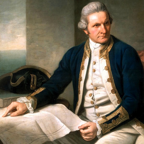
From the latitude and longitude given in the log Cook was uncomfortably close to Pinaki but it must be taken as a coincidence. Sailing directly from Cape Horn to Tahiti he was bound to head through the Tuamotus Group of Islands. Cook also explored the islands to the northwest of Tahiti which makes up the Tupai Trinity. A close scrutiny of HMS Endeavour’s Log and the diary of the mission’s botanist, Joseph Banks, reveals no hint of extracurricular activities suggestive of a search for a certain treasure lost by the Royal Society. Thankfully Cook and his mission are able to be eliminated from the story of the Great Lost Treasure.
This is not to say others thought likewise for Cook. The Tupai Trinity is remarkably similar in size and layout to the Pinaki Trinity but is found at 16 degrees South ,152 degrees West which in no way fits any permutations of the Star Code. It may have been the suggestive circumstances of Cook’s voyage which was instigated by the Royal Society that led searchers of the Treasure of God to follow his course and identify the Tupai Trinity. Then there is also the search for the lost treasure in the obscure south east corner of Terra Australis Incognito known as Queenscliff.

