The Star Code
Alchemy was not the only esoteric discipline that was used to encode the location of the Holy Graal; ancient lore about stars known as the Tetramorphs (or Watchers) was also used as they were closely linked to the teachings of Alchemy. Stars can be plotted using what is called the Equatorial Co-ordinate System which converts their position in the heavens into a form of latitude and longitude. The whole idea of using alchemy and stars seems to have come from Michael Maier’s 17th century alchemical book bizarrely titled ‘The Flying Atalanta’. In the ‘discourse’ accompanying ‘Emblem 27’ is a comment that was the template for the Star Code in all its mind warping complexity,
“If a man knows how to number well and distinguish the signs he will certainly find this Key in the Northern Hemisphere of the Zodiack, and the bolt in the Southern; and being Master of these it will be easy to open the Door and enter.”
The encoding principle is pretty easy to understand once you know it: refer to latitude and longitude by using a star’s name. In other words if you needed to identify a particular latitude and longitude just pick a star whose latitude (known as Declination) and longitude (known as Right Ascension) matched what you needed. This was easy as all you had to do was look these up in John Flamsteed’s ( a Royal Society member) Star Catalogue. If you wanted to be really sneaky you could just refer to the star by colour eg. The Red or The Yellow. In particular the Tetramorphs were used due to their link with Alchemy. All the related ancient lore covered here applies to the Northern Hemisphere only.
The Star Code
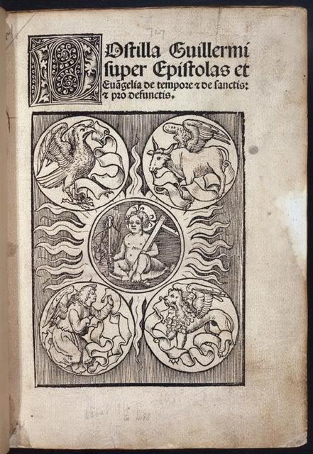
You will recognise the symbols given for each evangelist are the same as the four beings (Eagle, Bull, Man and Lion) that surround the throne of God in the bible. What may not be clear from this simple associative table is why Antares in Scorpio came to have the symbol of an eagle or Formalhaut in Piscis Austrinus (Southern Fish) came to be represented by a man.
For Antares, this was just the continuation of an ancient esoteric tradition that represented the scorpion symbolically by an eagle. It does not mean you associate the constellation of Scorpius to the constellation of the Eagle (Aquila), but just know that Antares is represented by the symbol of an eagle. For Formalhaut, its symbol came about by associating it with the ‘man’ in the nearby constellation of Aquarius (The Water Bearer). Again it does not mean you directly associate the
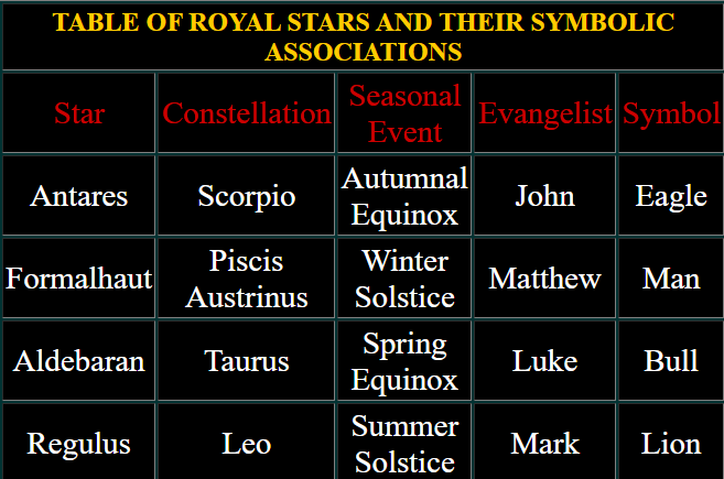
constellation of Piscis Austrinus with the constellation of Aquarius, only understand Formalhaut is represented by the symbol of a man. Each of these stars are what is known as the ‘Prime Star’ of their constellation, in a star chart they will be designated ‘Alpha’, eg Aldebaran is ‘Alpha Tauri’.
The Tetramorphs are considered to be a heavenly metaphor for the great cycle of life and regeneration shown by the strength of the Sun as it continuously waxes and wanes throughout the solar year. They are also a metaphor for the process of Alchemy that sees the glorious Philosopher’s Stone, an object living yet outside the cycle of life, arise out of the death of the base matter.
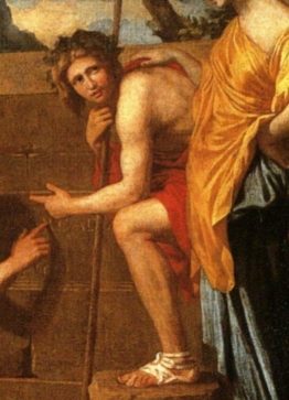
If you know the Tetramorphs, their constellations and the nearby constellations of the Zodiac then the Star Code is easy and brings new meaning to the alchemic saying ‘As above, so below’. In particular we are interested in the star Antares, the red Prime Star in Scorpius and also Capella, the yellow Prime Star in Aurigae that is ‘opposite’ Antares (next to Taurus) on the cyclic of the Tetramorphs. Look to Poussin’s ‘Shepherds of Arcadia II’ and the message of Alchemy it gives; the Red Shepherd and the Yellow Shepherdess. This was how Ubilla was able to give location of the cache by reference to two colours that stood for stars. A reference to one can still be found in the degenerate copy of the Webb report where it speaks about a ‘yellow stone’, though the English did not tend to use this original Spanish colour scheme much. Both the colours red and yellow can be identified in the directions used by ‘Diego Alverez’, a garbled form of which were reported in a book by Robert Charroux in 1962 titled ‘Treasures of the World’. Things might have been different for the story of Rennes le Chateau if people had taken more notice of this book rather than ‘Le Tresor Maudit’.
The application of this code will be shown later when the Webb report is correctly translated from Latin to show it identifies the Trinity at the Cero tres Puntas by giving the map’s central datum point of 138 degrees west of Greenwich.
The Red Shepherd points the way
As part of his Kidd hoax Harold T Wilkins gave the clue in a rhymed riddle how the Red shepherd, via the Star Code, pointed the way;
“Eyeless and hairless, on th’ island Pristarius, Kidd’s angels do lie,
They guard the Death Valley,
Through whose narrow alley,
Thee’st pass to the treasure,
Buried near fathom five.”
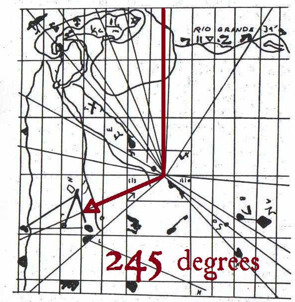
Pristarius is PRIme STAR scorpIUS, which is the red star Antares. Antares had a Right Ascension value of around 245.5 degrees in the 18th century. Simply, from the map’s central datum point you head 245 degrees to get to the Golden Section Triangle group of islands in which you then find the Trinity group.
The map escapes
As the story and copies of the map spread throughout the world many people began to search for the treasure. By the second half of the 19th century clandestine references to it all even began to appear in popular publications. In particular the Freemasons took great delight in putting coded references to ‘their’ lost treasure right in front of everyone’s nose where they could be seen but not recognised. There were two ways they did this. The first was by a completely fictional story that carried within it references to the treasure and signals only Masons would recognise. The other is what may be termed a ‘hoax/riddle’: a real sounding story complete with the names of actual people and locations that was a hoax but had within it a riddle or puzzle to solve. Again only a Mason would be able to recognise the signals and solve the riddle. Much mirth was to be had by the Freemasons watching persons follow their hoax stories!
Three Point Brothers
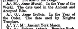
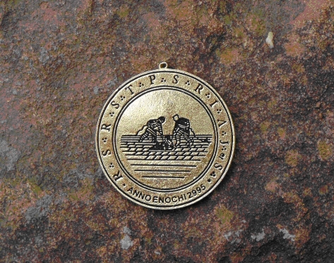
It should be said that the ‘Modern’ Freemasons (those who established the new lodges under Hanoverian rule in England around 1717) were never passed the secret by the ‘Antients’ (who were Stuart supporters). The Moderns were only imperfectly aware of the details and certainly were never passed the code keys. That is why Freemasons of today still talk about their ‘Lost Word’ but can never seem to find it. Here is a collection of reports and stories to show how well known this all was.
Adrift with Rear Admiral Hercules Robinson
In 1813 then Captain Robinson found himself summoned to the Admiralty and given a bizarre set of orders; take a male named ‘Christian Cruise’ to the Salvage Islands and search for a treasure. Cruise said he had received the details of the treasure from a Spaniard who lay dying from Yellow Fever in the hospital in Santa Cruz. Robinson’s ship, the Prometheus, sailed to the Salvage group of islands, which in those days were marked as a three island group (a Trinity) on naval charts. On Great Salvage Island Cruise identified that a beach of white sand (Playa Blanca) was the place to look. Unknown to Robinson was the reason Cruise managed to convince the Admiralty to undertake the search: Webb on his report had written “arrived at position lat 30 D 8 M”, the latitude of the Salvage group of islands. Nothing was found and the sailors had much fun skylarking on the beach. Robinson was bemused and somewhat perplexed by the whole affair. He wrote about it in his 1858 book ‘Sea Drift’ when he had retired after reaching the rank of Rear Admiral. He made the following ironic observation,
“Nor did the Admiralty of the day on receiving my report, which I conclude they did through Lord Amelius Beauclerk, think it worth while to the prosecute the matter further; and perhaps they thought they had bestowed as much attention on so vague a report as it was fairly entitled to. Had they gone further under authority, and with a king’s ship, it might have appeared like the credulity of Benedict Mol at the church of St Iago de Compostello, described by Borrow in his ‘Bible in Spain’, or of such visionaries.”
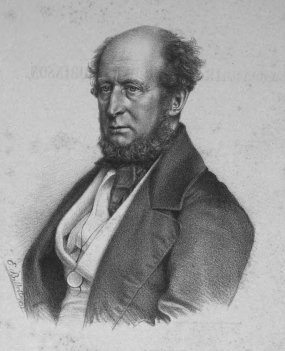
On the road with George Borrow
In 1835 while travelling in Spain George Borrow met a hulking ex-soldier, Benedict Mol, who tells him of his quest to find a treasure and is begging his way to Compostella,l
“My good German Herr,” said Benedict, “it is no church schatz, and no person living, save myself, knows of its existence: nearly thirty years ago, amongst the sick soldiers who were brought to Madrid, was one of my comrades of the Walloon Guard, who had accompanied the French to Portugal; he was very sick and shortly died. Before, however, he breathed his last, he sent for me, and upon his deathbed told me that himself and two other soldiers, both of whom had since been killed, had buried in a certain church at Compostella a great booty which they had made in Portugal: it consisted of gold moidores and of a packet of huge diamonds from the Brazils; the whole was contained in a large copper kettle. I listened with greedy ears, and from that moment, I may say, I have known no rest, neither by day nor night, thinking of the schatz. It is very easy to find, for the dying man was so exact in his description of the place where it lies, that were I once at Compostella, I should have no difficulty in putting my hand upon it; several times I have been on the point of setting out on the journey, but something has always happened to stop me. When my wife died, I left Minorca with a determination to go to Saint James, but on reaching Madrid, I fell into the hands of a Basque woman, who persuaded me to live with her, which I have done for several years; she is a great hax, and says that if I desert her she will breathe a spell which shall cling to me for ever. Dem Got sey dank, — she is now in the hospital, and daily expected to die. This is my history, Lieber Herr.”
Benedict manages to convince the authorities and public at Compostella the treasure could be found there. Unfortunately nothing is found when the floor of the ‘church of San Roque’ in Compostella is dug up. Benedict is last seen being dragged off to prison to the howls of the outraged mob. The whole sorry story can be found related in Borrow’s ‘The Bible in Spain’ published in 1843.
First of the Dying Pirates
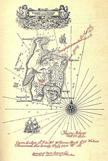
Captain Flint's real treasure map
Everyone knows the most famous pirate treasure book ever written, ‘Treasure Island’ by Robert Louis Stevenson. First published in 1881 as a serial in the magazine ‘Young Folks’, then as a book in 1883, it is considered to be a mere children’s story. Supposedly written for Stevenson’s young stepson Lloyd, it comes complete with a treasure map. Young Lloyd was said to have drawn the map to occupy his time in the wet Scottish highlands during a holiday there. Stevenson had then invented a story about pirates and a ‘treasure island’ to accompany the map. A little Masonic insight discloses this story and the map to be something more.
The story starts with the arrival of a mysterious sailor, William Bones, who dies to leave a map to the fabulous treasure island. But as Long John Silver discovers, the map will not lead you to the treasure because it has been relocated (as per the Webb report). The map that Stevenson (not Lloyd unless he was a Freemason also) drew for the book was drafted to embody some clues as Stevenson dimly understood them; that a triangular plot on an island shown on a map left by a dying sailor leads to the treasure. The directions given in the text, ‘Tall tree, Spy glass shoulder, bearing a point to the N. of NNE. Skeleton island ESE by E. Ten feet’, were again degenerate and a version of this was used by man named August Gissler to search for the treasure on Cocos Island. The Pan de Azucar/sailing mark makes it appearance also. It is marked ‘White Rock’ and is found on the small peninsula just above the notation ‘Skeleton Island’. Stevenson also tells of ‘Capt. Kidd’s Anchorage’ in the book that was said to be adjacent to Skeleton Island. This is where Wilkins got the title of his book ‘Captain Kidd and his Skeleton Island’.
To ensure that other Freemasons recognized the import of the story, Stevenson twice gave Masonic ‘signals’ or references within it.
The first occurs when we meet the character Ben Gunn who says, “As for you Benjamin Gunn, says they, here’s a musket they says, and a spade and a pickaxe.” This phrase is the literal symbolism of a Freemason’s tools. The same phrase is given for the lost treasure story told on Juan Fernandez Island.
The second occurs when a description is given of a log house built in a stockade on the island. Stevenson writes, “There was a porch at the door, and under this porch the little spring welled up into an artificial basin of a rather odd kind- no other than a great ship’s kettle of iron, with the bottom knocked out, and sunk to her bearings as the captain said among the sand.”
This is a signal by its reference to Chapter 47 of the Book of Ezekiel from the Bible. The Book of Ezekiel features heavily in Masonic lore as it sets out the dimensions of the Temple of Solomon. Chapter 47 commences, “Afterward he brought me again unto the door of the house; and, behold waters issued out from under the threshold of the house eastward”. The spring, the endless supply welling up, also has much deeper esoteric meanings.
Though badly distorted on the lower right you can still make out the shape of the bent knee of the kneeling shepherd from the monument’s tableau. On the upper left all that remains of the standing shepherd is a distorted head and the stub of an arm stretching out over the ‘tomb’.
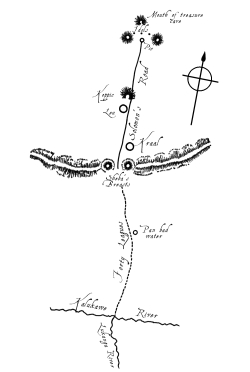
Quatermain's Trinity
‘Treasure Island’ has a Masonic brother, the book called ‘King Solomon’s Mines’ by L. Rider Haggard. The book displays an even deeper level of knowledge about esoteric subjects by the author but passes clues in a more direct form. The story behind the writing of King Solomon’s Mines goes that after reading Treasure Island, Haggard wagered one shilling with his brother that he could write a better story and much quicker. Written over the course of some months, ‘King Solomon’s Mines’ was published in 1885. Rather than the popularly accepted version of the one shilling wager, it is apparent that after reading Treasure Island and recognising what Stevenson was doing, Haggard was so unimpressed he decided to do a much better job of passing the coded clues to the great lost treasure and at the same time create a thrilling story. The story is about 3 men (Alan Quatermain, Sir Henry Curtis and Captain Good) who venture into darkest Africa to find the lost brother of Sir Henry at the fabulous location of the mines of King Solomon. Battling hardships, warriors and a witch, they enable a usurped king to regain the throne, visit the mines and in the end find Sir Henry’s brother.
Thought to be only a boys own yarn, it displays a remarkable depth of Masonic and esoteric lore ranging from the Masonic sojourn of three men to find King Solomon’s realm, philosophical insights provided by the usurped king Umbopa through to a discussion on the various guises of the goddess Astarte which is footnoted with a reference to Milton’s gnostic poem Paradise Lost. One particularly interesting detail is how they escaped entombment in the mines. After the treacherous witch sealed them in the treasure vault they make their escape by locating a ring set into the floor in the corner of the room. This ring lifted a trapdoor by which they could descend through successive levels until making their way out.
Masonic lessons aside, it is the directions used by the 3 men to get to the mines which show this story for what it really is.
Quatermain is in possession of a map to the mines that he obtained from a dying Portuguese named Jose Silvestre. Silvestre was found expiring after trying to follow a map and directions left by his ancestor also named Jose da Silvestre who had achieved the mines in 1590. The dying Silvestre is again replicating the details of Cornelius Webb, but this is the only version that expands the details so that a map has an accompanying directional text. You had to go to the left around the mountain peaks named ‘Sheba’s Breasts’ in a certain way. The map is more important to us at this stage and some editions will include an illustration of sorts to show how the location of the mines was located at “the three peaks of the mountain”, which was the result of ‘Cero tres Puntas’ being misheard as ‘Cerro tres Puntas’. A further phrase used by Haggard is that the three peaks are “in the form of a triangle”.
Valverde's Derrotero
Richard Spruce was a botanist tasked by the British Government in 1858 to gather plants of the Chicona tree (used as a source of quinine to combat malaria) in Ecuador. Amongst botanical observations in one of his notebooks is the ‘Derrotero de Valverde’ and one source identifies it was around 1860 that Spruce ‘discovered’ the derrotero in the archives of Latacunga. For those who don’t know a ‘derrotero’ is the Spanish word for a verbal route guide or ‘waybill’.
A complete backstory was provided that said that not many years after Pizarro had subdued the Incas, a poor Spanish soldier by the name Valverde, in the town of Latacunga, married an Indian girl, said in some versions to be an Incan princess. For some reason, given either as pity or the repaying of kindness, Valverde’s father in law discloses to Valverde the location of, or takes Valverde to the treasure cave that is in the Llanganati Mountains. Valverde is now rich and after many years returns to Spain. On his deathbed he composes the derrotero and has it passed to the King of Spain. The King sends the derrotero with a command to the Corregidors of Tacunga (Latacunga) and Ambato to find the treasure. A search party is raised which includes a Father Longo. On the trip, the party fails to find the treasure and Father Longo dies.
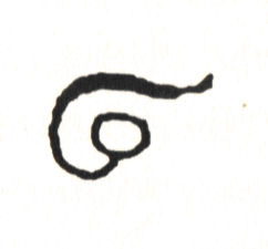
A preface to the derrotero text reads also, ‘Guide, or Route, which Valverde left in Spain, when death overtook/sized him, having gone from the mountains of the Llanganati, which he entered many times and carried off a great quantity of gold; and the King commanded the Corregidors of Tacunga and Ambato to search for the treasure; which order and guide are preserved in one of the offices of Tacunga’. The story took to popular imagination only after Spruce had died, as it was included in a 1908 book entitled ‘Notes on a Botanist on the Amazon and Andes’. This was a compilation of Spruce’s writing assembled by a colleague named Alfred Russell Wallace which included a reproduction of something called the ‘Guzman Map’, an original engraving of which is in the Royal Geographical Society in London. Anasio Guzman was a real Spanish botanist, pharmacologist and miner who mapped the area in the early 1800’s. Guzman’s Map, identified by Spruce to be used with the derrotero does not mark or identify the target, the socabon (tunnel) containing the gold. It is just a map depicting salient geography and features of the region, though illustrated in a rather lurid style. You had to follow the derrotero to a wild region known as the Llanganati Mountains to find the three Cerros Llanganati. To get there you had to pass round ‘on the left hand’ a mountain of ‘margasitas’. A glyph in the middle of the derrotero illustrates how (shown left). By following the directions you achieve the socabon in which the ransom treasure of Atahualpa Inca was stored after he was murdered by Pizarro in 1532.
It is no coincidence that the exact phrase used in Valverde’s Derrotero to describe the layout of the three Cerros Llanganati, “in the form of a triangle”, was used word for word by L Rider Haggard in King Solomon’s Mines. Haggard even gave a similar directional instruction pertaining to a mountain as the one given for the mountain of ‘margasitas’ and demonstrated by the glyph, “Let him who comes follow the map, and climb the snow of Sheba’s left breast till he reaches the nipple, on the north side of which is the great road Solomon made…..” Everyone seemed to miss the obvious pointer that the whole thing was a hoax: the name of the priest that sparked off the slaughter of the Incas by Pizarro was Vincent Valverde.
A parchment
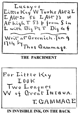
In 1888 a book was published in New York called ‘Captain Kidd’s Gold’ by James Franklin Fitts, a supposedly true story. It tells the story of the search for treasure buried in the Bahamas by one of Kidd’s crew. A dying sailor who had come into possession of the secret from another old sailor, who had died in Greenwich hospital, passed the written directions (not a map) to his son. The directions are shown left. The style and format of the ‘parchment’ was later copied by Harold T Wilkins as part of his ‘Captain Kidd’s Treasure Charts’ hoax, not that anyone noticed.
The Astor's source of wealth
A numeric example of the Golden Section appearing as a clue can be found in the Masonic hoax/riddle known as the Olmsted Story. This was another elaborately constructed hoax/riddle written by Frank Head in 1894. In it he used real locations and spoke of real people, the Olmsteds, who owned a house on Deer Island (Maine, USA) where the story is set.
The story tells how Kidd was supposed to have passed a card to his wife in Newgate prison upon which were the numbers 44106818. The card was seized by prison guards and ended up in the court records. Olmsted obtained photographs of these court records which included an image of the card. One day a guest at the Olmsted’s house, an astronomer, idly works out the latitude and longitude of the residence to be 44 degrees 10′ North 68 degrees 13′ West. Olmsted’s daughter recognises the latitude and longitude to be similar to the numbers appearing on Kidd’s card. The Olmsteds subsequently discover that a Mr. Jacob John Astor (a wealthy entrepreneur of the time) had taken a treasure from their land on Deer Island some years before. They then commence curial action to have the treasure returned. The variation between the figures 44106818 to the actual latitude and longitude of Deer Island is explained in the story as being due to the inaccuracy of Kidd’s chronometer.
The trick in this Masonic riddle is to know that the author is drawing your attention to what the number should be; 44106813. The number 44 is itself a mistaken variation of the number 42. As a clue the numbers given after 44 should be recognised as the Golden Section, 1.61803. A variation of this cipher can be found on the ‘Hautpoul’ gravestone in the story of Rennes le Chateau. That version however gives the number 42 and the Golden Section.
Trinity Land
In 1897 another book titled ‘Captain Kid’s Millions’ was published. It had a rambling storyline that suggested ancestral memory and descendant fate. The author was Alan Oscar but this is just the nom de plume of William Boultbee Whall.
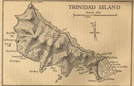
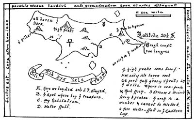
William Kid (a descendant of an earlier James Kid) has a treasure map and is on Trinidade Island. The map he has identifies ‘Trinity Land’ but he still finds the treasure by chance. A huge wave, caused by a minor earthquake, sweeps the island exposing a flat rock. On it was engraved a cross and “the ancient symbol of masonry”, an Egyptian ankh. This is a reference to the Ebanin. Beneath the rock was an ironbound chest containing pyx, monstrance and jewelled cups etc. Keeping a small portion of the treasure, he reburies the chest at another location (the relocation again) and marks its position in code on a map he made of the island (shown left). This chart is used later by another descendant named Richard Kedde.
The map shown in the story can be seen to be replicating the shape of the shepherdess again, which along with the actual shape of Trinidade Island and the code word ‘Trinidad’ suggests this is the island to look. A good pointer is the Alchemic symbol shown for Mercury drawn on the island and also the Ankh (this symbol is more Masonic). The Pan de Azucar is marked on the map. This feature is to be found at the same position on Trinidade Island. The story identifies the treasure was in a cave in this area, again the same position relative to the Golden Section Triangle plotted on the combined monument map.
Trinity Land for Real!
Edward Frederick Knight (Barrister) was a true gentleman adventurer who fell under the allure of a familiar sounding tale and had a familiar sounding fate; he went on an expedition to a remote location and found nothing but hardship. His book, ‘The Cruise of the Alerte’, published in 1890 is written in a format that was to be repeated many times: set out the true (?) story of the dying sailor who left a treasure map, give an account of his own trip to the location shown on the map and then end with an explanation about why the treasure could not be found.
The map was on an old piece of tarpaulin and it seemed to indicate the treasure was buried under the ‘Sugarloaf” (Pan de Azucar). Supposedly it consisted of looted plate and ornaments from the cathedral of Lima. Amongst the riches were ‘several massive golden candlesticks’. If everyone had used the correct word, Menorah, it might have been obvious a lot earlier what they were really searching for.
Apart from the map,
“The pirate had described a small gully in the middle of this bay, at the foot of which he (the pirate) and his men had erected 3 cairns, which should serve as landmarks to those who had the clue, and point the way to the treasure.”
Unfortunately only traces of these cairns could be found as Mr A- (an earlier searcher who had given the map to Knight) had obliterated them with gunpowder. Luckily, Mr A- had already communicated that he understood they led to the first bend in the ravine where the treasure had been buried under a hollow rock. They found where Mr A- had dug into a landslide that had intruded into the ravine but doubt immediately crept in whether this was really the correct location. Observing that the ravine had many bends big and small, they found it was open to subjective interpretation which of these was the ‘first’ bend. Three months later they gave up digging and went home.
The cairns erected by previous searchers were just attempts at plotting the triangle shown on the copy of the combined monument map they had onto the actual landscape of the island. The same thing occurred on Oak Island in Nova Scotia.
Part of this map was also copied by Harold T Wilkins as a recognitive signal for his ‘Moose Island’ map as part of the ‘Captain Kidd’s Treasure Charts’ hoax.
