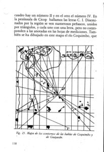
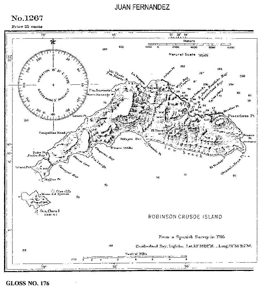
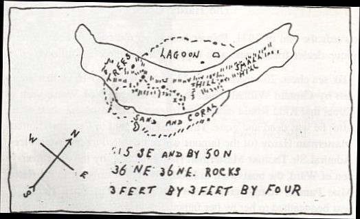
1. Take Ubilla’s map and measure the angular divergence in degrees between pairs of lines. We shall call these ‘bearing sets’. Do it for all lines around the map. A pattern will develop of repetitive bearing sets.
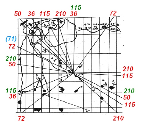
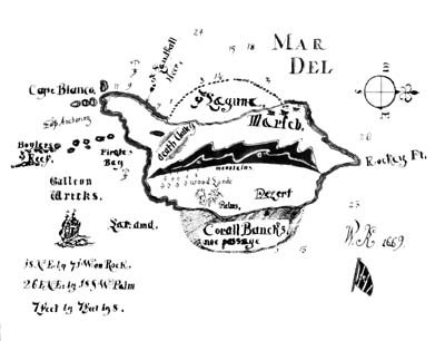
You’ll come up with 36, 72, 50, 115 and 210. Some lines are common to different sets. Those that are common to more than one set will have two values shown, one in red and one in green. The values should be familiar as some appear on the 1932 Kidd hoax map. The deliberately unclear number that followers of the Kidd maps take to be 515 is just the 115 degree bearing set. Don’t fall for Skelton’s suggestion that it was 515. Further, if the line radiating from the centre marked 50 on Ubilla’s map (top left corner) was made an arbitrary ‘north’ then the radiating line two to the right (marked 115) equates to 18 degrees and the next line (marked 210) equates to 26 degrees. These are two of the numbers that appear as bearings on the Mar Del W1 map.
The importance of the value of 115 is that it is the mirror reverse of the Antares bearing (245). Anyone using an image of the monument map in reverse (which some did) would now be following this 115 degree bearing. Just remember this 115/515 pointer. It will appear again as a clue for the hoax/riddle known as ‘Rennes le Chateau’.
2. Next, the coastline of Guayacan as it appears on a modern chart needs to be compared with the coastline of Juan Fernandez from the ’25 cent’ map. This will reveal the coastline of Guayacan replicates the depiction of the coastline of Juan Fernandez but in a much smaller scale.
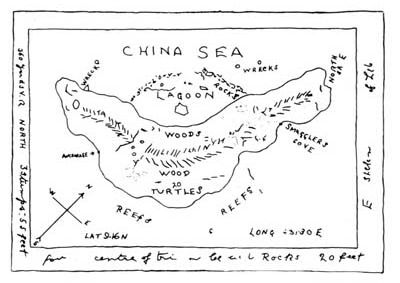
3. Look then to the compass drawn on the Kidd maps that is both pointing to what can be equated to the position of Cumberland Bay on Juan Fernandez. This is instructing a certain north/south, east/west alignment is to be used.
4. Check where the three dots are located on the Kidd ‘turtle’ map and use the notation , ‘360 yards V.R North’ as this means ‘360 yards, Valley Runs North’. It is an instruction that some important position is to be located on the 25 cent map which equates to a distance 360 yards north into Cumberland Bay using the specific north/south, east west alignment.
5. Plot this position on the map of 25 cent map for Cumberland Bay and shoot the directional bearings from the Kidd map 36, 50, 72 (2×36) and 115. These will shoot to some distinct locations on the map.
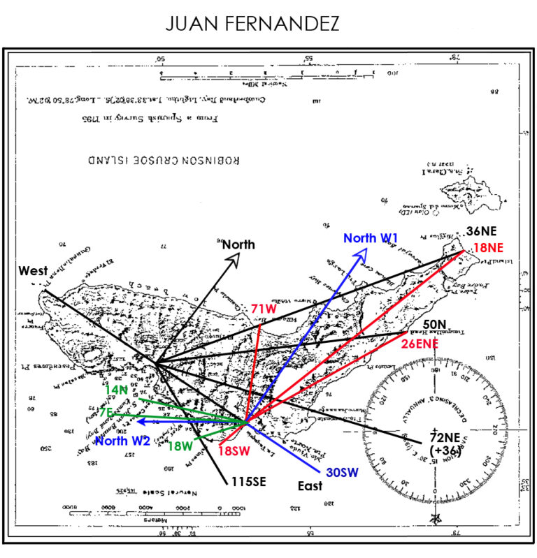
6. Move along the ‘east- west’ line of the original plot for Cumberland Bay to English Bay and then parallel the arbitrary ‘north line’. From a point in English Bay shoot the bearings on the Mar Del W1 map, ‘18NE by 7i(1?)W on Rock. 26ENE by 18SW Palm’. These will cross reference the same features the 36NE and 50N bearings from the Cumberland Bay plot shoot to.
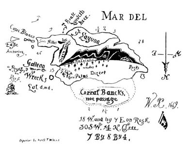
a. From this same position in English Bay, also shoot Mar Del W2 map’s bearings ‘18W and by 7 E on Rock, 30SW. 14N. Tree’ but this time set the arbitrary ‘north’ to true east for Juan Fernandez. These bearing then appear to cross reference the ‘115SE’ bearing from the Cumberland Bay plotting with 30SW overlaying the ‘east-west’ line.
Latcham gave a clue to this in his book when he said,
“It is curious to note the direction of the cardinal points, as much on the map as on the plan. On the map, north gives the direction that is truly the east, and on the plan, north points towards the southwest.”
A further clue is the notation being devoured by the turtle on the Kidd ‘turtle’ map, ‘NORTH SA E’ which means ‘North same as East’. These clues are Masonic in origin as Masons, as detailed previously, drew their maps with East at the top rather than the accepted convention of placing North at the top.
You should also be tipped off by the Kidd maps’ compass heading for ‘north’ as this bears no relationship to the real direction of north for Juan Fernandez Island. It is just a construct demonstrating an arbitrary alignment to be used for the puzzle; the ‘north’ is just made up, so too then are the directions of ‘west’, ‘east’ or ‘south’. This was a major part of the riddle’s subterfuge as it allowed those with the preconceived and incorrect notion that the compass and directions were based on true/grid north for Kidd’s mythical island to interpret it all that way. The compass here is just being used as a device to identify where you should look; either left or right (or upper left or lower right etc) of the arbitrary alignment when shooting a bearing given as part of the puzzle. For example, 26ENE has no relationship with the true direction of East North East. The numbers are obtained by measuring the bearing sets on Ubilla’s map; they have no directional component. The apparent direction ‘30SW’ given on the Mar Del W2 map is just another way of saying 210 degrees from the arbitrary ‘north’. Again, it is just a number that appears as a bearing set on Ubilla’s map.
To confirm you have recognised the clues and are correctly working through it all, Wilkins placed bearings on the Mar Del maps that cross reference some of the features marked by bearings from Ubilla’s map for the 25 cent map.
There is one anomaly that cannot be fathomed fully though. On Ubilla’s map there is bearing set identified as 72 (71). The number you would be looking for is 72 but this bearing set actually produces an angle of 71 degrees. This seems to relate to the direction 7iW on the (W1) Mar Del map. It is considered this may have been Wilkins drawing attention to the number 71 by writing it 7iW.
Having unlocked the puzzle of the maps for Juan Fernandez it is now time to apply what has been learned for the puzzle Latcham set around Guayacan.
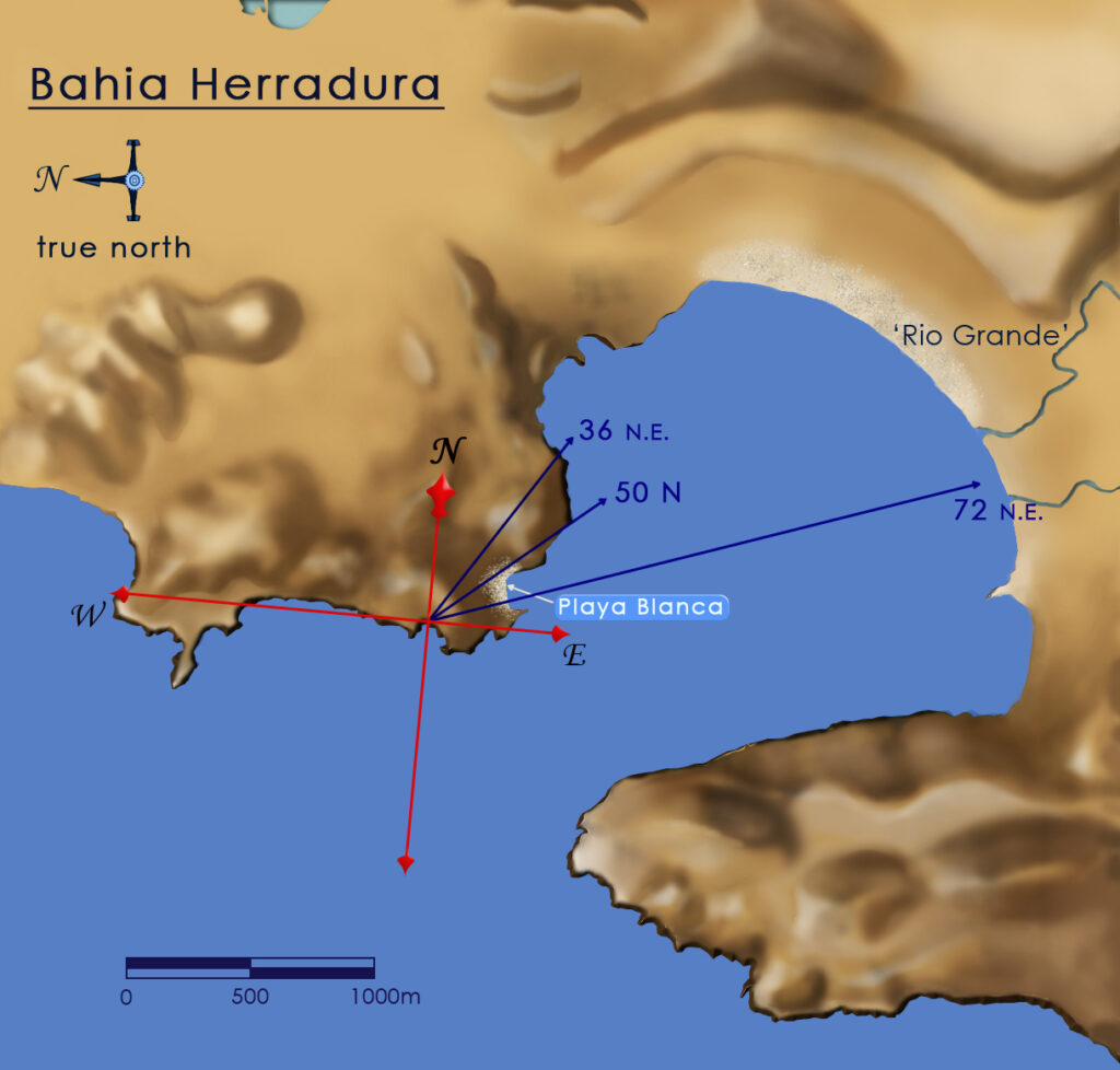
The same arbitrary compass alignment is to be used for a small cove on the coastline of Guayacan. This is because a study of the coastline of Guayacan near Playa Blanca will reveal that it replicates the coastline of Juan Fernandez (as shown on the 25 cent map) on a smaller scale. The smaller cove in the coastline of Guayacan is to be equated to Cumberland Bay on Juan Fernandez. Here, though you still use the same arbitrary ‘north’ as for Cumberland Bay, this ‘north’ really faces true east. Accordingly the map for Guayacan used to illustrate this will be oriented this way. True east is now at the top of the map (North same as East) where the arbitrary north points.
The plot for Guayacan Bay shoots the 36NE and 50N bearings to the same shaped features as can be found on Juan Fernandez. Of note is the coastal shape marked by 36NE; it is suggestive of the ‘mouth’ shaped cove shown on the 25 cent map of Juan Fernandez that was caricatured into the turtle’s mouth on the Kidd ‘turtle map’ of Juan Fernandez Island. Of interest also is the 72NE bearing which now shoots across the bay to two river channels that are suggested by the ‘Rio Grande’ notation on Ubilla’s map.
Note the distinctive ‘horseshoe’ shape of Bahia Herradura (Horseshoe Bay). This replicates the shape on an inner lagoon of a South Pacific ring atoll. The relative area of the search for the treasure on the ‘horseshoe’, here the north west sector, can be found being searched in other similar shaped bays where this treasure legend is told also.
For those following the real trail and working out the riddle it is all really an instructive puzzle designed to teach you how NOT to use Ubilla’s map. By getting you to work it all out yourself you then learn how other searchers were misreading and misinterpreting copies of Ubilla’s map in their searches of Juan Fernandez Island and Guayacan. In other words, measuring the angles of the lines radiating from the centre of Ubilla’s map to produce bearings to landmark locations is the wrong thing to do.
You might have noticed the curious mix of handwriting on the the Kidd ‘turtle map’ of Juan Fernandez Island. Both Wilkins and Latcham wrote on it just so you knew who drew it. The notation ‘E ske??? Of Le?’ on the turtle map are just Latcham and Wilkins telling you the map is an ‘Explanatory sketch of Legend’.
You are here now because for all those decades no one bothered to check the handwriting when they investigated Captain Kidd’s Treasure Charts.
Nor did they follow the obvious clues Wilkins put in his books or his other writings.
Wilkins, in ‘Modern Buried Treasure Hunters’ (1934), mentions the story of a watchmaker in Toronto who finds a map in a pocket watch. In the book there is no illustration of this map but if a careful search is made a magazine article by Wilkins can be found which does reproduce an image of the tiny map in the watch.
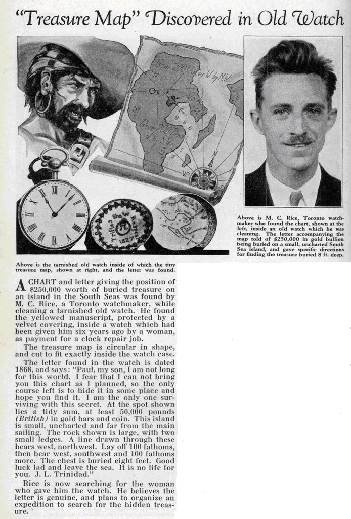
This story that Wilkins wrote tells of an important rock from which measurements are made upon “an island in the South Seas”.
Anyone with imagination might just recognise again that the particular bay shape is very similar again to the inner lagoon of a South Pacific ring atoll. Wilkins was really hinting again at the horseshoe shape of a certain island somewhere there.
For Wilkins, Latcham and their Captain Kidd’s Treasure Charts hoax it was the turn of history again that put a halt to their plan.
World War Two erupted and things were never the same again.

